

African Union Pushes for Maps That Show Continent’s True Size: Challenges Global Misrepresentation

The African Union (AU) has thrown its weight behind a global campaign calling for the replacement of the centuries-old Mercator map projection with one that more accurately represents Africa’s true size and position in the world.
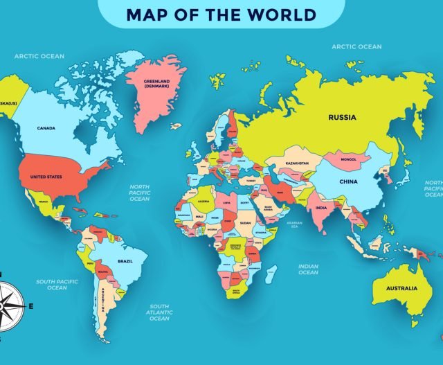
The Mercator projection—developed in the 16th century by cartographer Gerardus Mercator for navigation—enlarges landmasses near the poles, such as North America and Greenland, while drastically shrinking Africa and South America.
Beyond Geography: A Question of Identity
“It might seem to be just a map, but in reality, it is not,” AU Commission Deputy Chairperson Selma Malika Haddadi told Reuters. She explained that the distortion has long fueled stereotypes of Africa as marginal and insignificant, despite being the world’s second-largest continent and home to over a billion people across 55 nations.
Haddadi stressed that such portrayals shape education, media narratives, and even global policymaking. The AU’s endorsement of the campaign, she added, reflects its broader mission to “reclaim Africa’s rightful place on the global stage” amid ongoing calls for reparations for colonialism and slavery.
Correcting the Map
The “Correct The Map” campaign—led by advocacy groups Africa No Filter and Speak Up Africa—is urging governments, institutions, and schools to adopt the Equal Earth projection, a 2018 map that provides a more realistic representation of country sizes.
“The current size of Africa on the map is wrong,” said Moky Makura, Executive Director of Africa No Filter. “It’s the world’s longest-running misinformation campaign, and it simply has to stop.”
Fara Ndiaye, co-founder of Speak Up Africa, noted that the Mercator projection has long undermined African pride and identity, especially among children first introduced to geography through distorted maps. “We’re working on promoting a curriculum where Equal Earth becomes the standard across African classrooms,” she said.
Global Shift Underway
Some organizations are already moving away from Mercator. The World Bank now uses the Equal Earth or Winkel-Tripel projection for static maps, while Google Maps switched to a 3D globe on desktop in 2018, although Mercator remains the default on mobile.
The campaign has also reached the United Nations, with advocates submitting a request to the UN’s geospatial committee for formal review. Meanwhile, support has come from other regions, including the Caribbean Community (CARICOM) Reparations Commission, which called Equal Earth a rejection of the Mercator’s “ideology of power and dominance.”
What It Means for Africa
For the AU, adopting a map that reflects Africa’s true size is more than a symbolic correction—it is a step toward reshaping global perceptions of the continent’s importance, power, and future potential.
Reuters